Ottawa Region hosts third in the “Across Canada Workshop Series” on Resilient Rainwater Management (Oct 30)
Note to Reader:
The article below introduces the Rideau Valley Conservation Authority (RVCA), host for the Ottawa event in the Across Canada Workshop Series, and previews the workshop content. The article is structured in two parts – local context and British Columbia perspective. The objective is to inform a Rideau Valley target audience as to the relevance and value of the workshop.
The first part is written from the RVCA perspective, It introduces the significance of Ontario’s Provincial Policy Statement in providing direction to ensure the hydrologic integrity of watersheds. The second part presents a complementary British Columbia perspective on how application of science-based understanding will help achieve this desired outcome.
![]()
Partnership for Water Sustainability in BC will visit Ottawa on October 30, 2014
The Rideau Valley Conservation Authority (RVCA) is partnering with the Partnership for Water Sustainability in BC to host the third in the five-city “Resilient Rainwater Management: Across Canada Workshop Series on Adapting to a Changing Climate”.
 “RVCA welcomes the opportunity to participate in the Across Canada Series,” reports Don Maciver, RVCA Director of Planning and Regulations. “RVCA staff believe that a workshop event such as this allows staff and our community partners an opportunity to learn about potentially different ways to manage stormwater runoff in urbanizing and changing watersheds; from different ways of focusing conservation authority and municipal policy development to novel Low Impact Development solutions / Best Management Practices (BMPs).”
“This workshop was seen an accessible means to learn about how British Columbia is attempting to reduce the impact of traditional stormwater management policies and practices; and to learn about the water budget analysis tool that they have developed.”
About RVCA
The Rideau Valley Conservation Authority is an environmental protection and advisory agency that works with local municipalities, government agencies, special interest groups and the general public. The RVCA strives to protect watershed resources. “Our goal is to have clean water, natural shorelines and sustainable land use throughout the Rideau Valley watershed,” states Don Maciver.
For Workshop Registration Information:

Ontario’s Provincial Policy Statement & Hydrologic Integrity of Watersheds
“As more and more areas within the Rideau Valley watershed are built over or otherwise culturally modified, RVCA staff know the importance of ensuring that key components of the natural hydrologic cycle are preserved and to thereby address Ontario’s Provincial Policy Statement (PPS),” continues Don Maciver.
“RVCA staff note that the 2014 PPS reiterates the need to maintain the hydrological integrity of our watersheds. The PPS stipulates that Ontario municipalities must:
“protect, improve or restore vulnerable surface and ground water ….” and “ensur[e] consideration of environmental lake capacity”
The PPS, on which the planning and technical advice that RVCA provides to our municipal partners is based, indicates that planning for stormwater management must address: contaminant loading; water balance and erosion; and risks to human health, safety and property. Further, local policies and practice must also:
“promote stormwater management best practices, including stormwater attenuation and re-use, and low impact development” and “maximize the extent and function of vegetative and pervious surfaces[.]”
The local presentations slated for October 30th were chosen by RVCA staff to speak to two important aspects of the above.”
Water Budget Assessments to Protect Groundwater-Supported Ecosystems
The Ontario Ministry of Environment partitioning method (1995) using water balance values derived from Thornthwaite and Mather (1957) can provide an accurate basis for calculating Water Budgets on a watershed, subwatershed, site, and feature-based scale. However, this method only accurately reflects natural conditions when modified based on an understanding of the geological, hydrogeological, hydrologic, and ecological conditions.
To provide a local technical context for the day, an overview presentation by Jason Cole will focus on the use and application of the Thornthwaite and Mather method as part of the modified MOEE method to inform stormwater management decisions, understand the potential impacts from development, and provide a basis for protecting groundwater supported ecosystems, watercourses, and aquifers.
Jason Cole is a Professional Geoscientist with nine years of experience conducting hydrogeological investigations in support of design and permitting for large infrastructure, land development and mining projects.
City of Ottawa: “Getting Our Feet Wet” with Low Impact Development
A presentation by Darlene Conway will provide an overview of the local context and outline steps the City of Ottawa is currently taking to incorporate the reduction of runoff volume in greenfield developments and older, established neighbourhoods.
Darlene Conway is a Professional Engineer who has been practicing for 25 years in the area of stormwater and floodplain management. After working in consulting for almost a decade in the Greater Toronto Area, Darlene spent 5 years with the Toronto and Region Conservation Authority. For the past 12 years she has been a Senior Project Manager with the City of Ottawa, focusing on master planning for stormwater management infrastructure.

Workshop is An Opportunity to Learn About BC’s Approach to Protecting and Restoring Watershed Health
The workshop series showcases the case study experience of those local governments leading change in British Columbia. Also featured are various web-based tools, in particular the Water Balance Model Express for Landowners, which support implementation of BC’s new Water Sustainability Act.
“The workshop storyline is comprehensive and covers the continuum from developing provincial policy and tools to implementing actions on the ground. Science-based understanding provides the foundation for a water balance approach to community design,” states Ted van der Gulik, Partnership President, and a member of the 3-person BC presentation team.
Below, a technical segment of the workshop storyline is previewed because of its particular relevance to the local Rideau Valley context for implementing Ontario’s Provincial Policy Statement. This extract draws attention to the important role that soil science understanding plays in achieving water balance solutions.
Workshop Emphasis is on Understanding the Natural Water Balance & Flow Paths to Streams
“British Columbia was the first province to adopt the Water Balance Methodology. At the workshop, we will explain WHY provincial direction is to mimic the natural Water Balance,” states Kim Stephens, Partnership Executive Director. He is the leader of the BC team that is delivering the Across Canada Workshop Series. “However, our emphasis will be on HOW the Water Balance Methodology has evolved over the past decade; and HOW to develop performance  targets that mimic the natural Water Balance.”
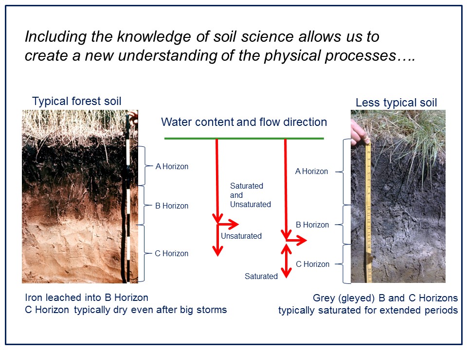
“The Water Balance Methodology synthesizes the fundamentals of hydrology, aquatic ecology, geomporphology and hydrogeology. Also, incorporating soil science knowledge allows us to create a new understanding of the physical processes associated with the flow paths of water in the watershed, and flow in streams.”
“Our vision in BC is that community development activities and alteration of the Built Environment will result in cumulative benefits, not impacts.”

Where Does the Groundwater Go?
“The three pathways by which rainwater enters streams are surface runoff, horizontal flow known as interflow in shallow soils, and deep groundwater,” continues Jim Dumont,  the Partnership’s Engineering Applications Authority.
“At the heart of the Water Balance Methodology is recognition of the integrated significance of these three flow paths, the period of time required for rainwater to reach the stream via each flow path, and the need to protect and maintain the natural distribution of rainwater via each flow path.”
An Introduction to Soil Science Principles
“The topic of shallow and unsaturated groundwater discharge has been undergoing change over the past 10 to 20 years. Prior to that surface hydrologists thought it unimportant,” observes Jim Dumont.
“Many references indicate that up to 90% of all rainfall infiltrates into the ground. That being the case, it then becomes critical to know the fate of the water where volumes are critical. As an industry of engineers, if we typically deal with only the 10% as surface runoff, are we really comprehending hydrology?”
Soil Moisture Reservoir: “The part of the lessons learned comes from some simple soil physics that differentiates in the soil moisture reservoir. A very basic introduction to soil water relationships is critical in understanding the link between rainfall and underground aquifers.”
“A big part of the shallow surface soil is its ability to act as a reservoir in which the drainable portion depends upon the soil texture and a bit on topography and a lot on the processes that created the soil. A key is that the soil will become saturated, but it will take a few days to drain down to Field Capacity. This is potentially a very large volume when spread over a watershed.”
Downwards and Sideways: “Where does this water go? Some would say downward, yet the evidence supplied by the soil indicates this is not the case. The soil reservoir will drain both downwards and sideways.”
“The evidence in the soil is obvious where the soil’s ‘C Horizon’ remains little changed by the influence of water movement from above. The definition of the C Horizon is that it is the Parent Geological Material which has not been altered by biophysical or chemical processes. Therefore, the C Horizon is seldom saturated, and possibly it never gets saturated. One can observe this soil condition by examining a fresh construction excavation shortly after a heavy rain.”
“This information implies that water seldom penetrates to saturate all layers of soil and in particular the C Horizon. If water does not penetrate to saturate the C Horizon, then it must drain through an unsaturated soil in pathways which are both sideways and downward,” concludes Jim Dumont.