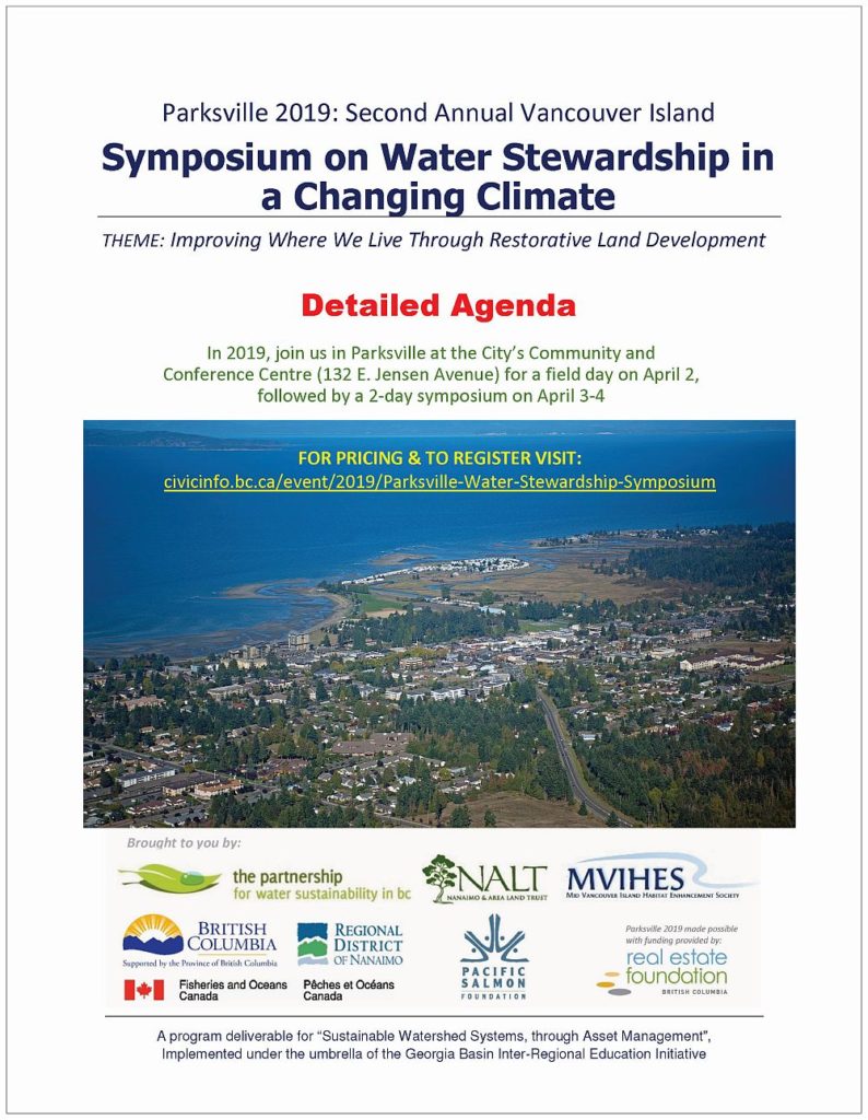
MODULE B – DAY TWO – PARKSVILLE 2019 SYMPOSIUM: A Panel & Town-Hall Session on “Improving Where We Live” features five Vancouver Island initiatives to demonstrate what is possible through a Whole-System Approach
Note to Reader:
Click on PARKSVILLE SYMPOSIUM AGENDA to download a package that elaborates on the presentation topics in each of the four modules that comprise the program on each symposium day. Parksville 2019 is a call to action. Read together, the set of abstracts create a seamless storyline that is designed to inform delegates so that they will know what to expect on April 3-4 when they convene in Parksville.
MODULE B: Panel & Town-Hall Session: Improving Where We Live
“A vision for restorative land development could be guided by the mantra: Sustainable is attainable. We can make where we live better. While communities cannot restore lost biodiversity, they can halt its decline and consciously direct efforts into bending the trend-line in an upwards direction. ‘Getting it right’ is a process that requires long-term commitment, patience  and perseverance by champions,” states Kim Stephens.
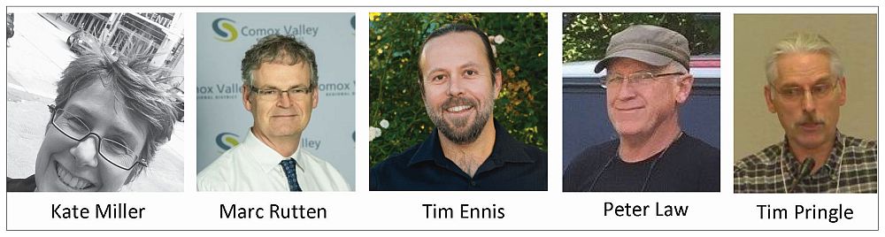
“A 5-person team will prime the audience with 5-minute vignettes about long-term and emerging initiatives in regional districts on the east coast of Vancouver Island.
“Inspirational in scope, these demonstrate what is achievable when there is a restoration imperative. The town-hall segment will focus on how the lessons learned to date might inform the RDN’s Drinking Water & Watershed Protection (DWWP) Action Plan update.”
Ignite Format for Storytelling
“Each panel member has 5 minutes to tell his or her part of the panel storyline. The objective in ‘presenting at them’ is to prime the audience for town-hall interaction. Hence, the panel presentations must be streamlined and past-paced,” explains Kim Stephens.
“We want the audience to be champing at the bit to have a conversation to learn more. So, we are asking panel members to apply the Ignite format. The result will be a fast and fun set of presentations.
“Ignite is a presentation format that’s simpler than Pecha Kucha but longer than lightening talks. In Ignite each speakers gets 5 minutes, and must use 20 slides with each slide advancing automatically after 15 seconds, forcing speakers to get to the point, fast.
“Having slides that automate seems mad, and in a way it is, but the surprise is that for most speakers it forces them to be far more concise and thoughtful than they would in any other format.
“The one refinement that we are making is to specify that each speaker can use up to 20 slides. This gives some flexibility. But the 5 minute limit still applies.”
Town-Hall Interaction
“Panelists will engage with the audience to explore lessons learned from experience in leading change,” concludes Kim Stephens. “Just as in the town-hall on Day One, emphasis will be on the value of ‘citizen science’ and how it can be leveraged to achieve two complementary objectives: educate the local community (public); and inform alignment of provincial, regional and local actions so that restorative land development results in sustainable stream restoration.”
Poised for Action in the Cowichan Region: Embedding Change through the Drinking Water & Watershed Protection Service
Watershed planning is a way of integrating land use planning for communities with other impacts in watersheds to ensure that all the resources are managed effectively. In October 2018, Cowichan electors passed a referendum (by a decisive 66% in favour) to implement the new regional service. This is the culmination of more than a decade of collaboration to build capacity in the stewardship sector and enhance decision-making.
Sustainable Funding
“As an innovative and leading example of local water protection, the Cowichan Valley Regional District (CVRD) has secured sustainable funding through taxation to establish a Drinking Water and Watershed Protection Service to support regional programs related to drinking water and watershed protection,” states Kate Miller, Manager of Environmental Services, Cowichan Valley Regional District.
 “Drinking water and watershed management are consistently identified as priority issues in the region—similar to many communities across British Columbia and Canada.
“In the Cowichan, increasing water use and a changing climate impact watershed health. Water quality and quantity challenges exist across the region’s 16 watersheds, with numerous water users operating independently and in an uncoordinated way.
“Establishing support for better collaboration among these various water users and purveyors, as well as improved cooperation among decision-makers, will catalyze a more comprehensive and integrated approach to watershed health.
“The service makes new and enhanced forms of collaboration possible, and allows for better sharing of resources, data, and support for freshwater sustainability.”
Comox Lake Watershed Protection Plan:
Collaborative Process = Community Support
The plan was developed by the Watershed Advisory Group (WAG), a comprehensive group of stakeholders representing a broad variety of interests. Along the way, the process fostered relationships and built trust among the many stakeholders, including all four local governments. The Watershed Protection Plan is truly a collaborative outcome. But a plan is nothing without follow-through and implementation. We’ve got the support. This plan will not sit on a shelf.
Regional Water Source
“Lake provides drinking water for 45,000 people in the Comox Valley,” reports Marc Rutten, General Manager of Engineering Services Branch. “The essence of the story is that the Watershed Advisory Group (WAG) delivered a Watershed Protection Plan that was fully implementable, and WAG did it within a year.
 “The Watershed Protection Plan is truly a collaborative outcome. And most importantly, it is fully funded. It will not sit on a shelf. The process fostered relationships and built trust among the many stakeholders, including all four local governments.”
“Protecting our drinking water requires two important steps: treating the water and protecting the source. The area of land that drains into Comox Lake is approximately 461 square kilometres; and the majority is K’ómoks First Nation (KFN) traditional territories or privately owned.
“Balancing interests such as private ownership, active logging, recreation and hydroelectric power generation, while sustaining critical fish and wildlife habitat, provides challenges for watershed management.”
Kus-kus-sum Restoration on the Courtenay River:
Transforming a Decommissioned Sawmill Site into a Valuable Habitat Corridor
Decommissioned in 2006, the Field Sawmill was once the economic heart of the Comox Valley. A First Nation, a municipality and an environmental non-profit share a dream and have signed an MOU to collaboratively purchase, restore and manage this key property in the heart of their community. This is an historic milestone in reconciliation and intergovernmental relations.
Field of Dreams
“Estuaries have long been the location of choice for coastal BC’s saw and pulp mills. Hindsight is 20/20. By the 1980s many of BC’s coastal communities were waking up to the fact that salmon populations, herring, and waterbirds were in decline to over- industrialization of many of the province’s most important estuaries,” states Tim Ennis, Executive Director of the Comox Valley Land Trust, in providing an historical context.
 “The Comox Valley Project Watershed Society and the K’ómoks First Nation share a dream for the future of the Field Sawmill site. Known to the K’ómoks people as ‘Kus-kus-sum’, the property holds deep significance. The City of Courtenay has similarly embraced the restoration dream.
“As part of the Kómoks Estuary, the restored area at Kus-kus-sum would provide fish and wildlife habitat, help mitigate climate change, buffer against sea level rise, attenuate localized flooding, become a culturally significant landmark and provide educational and recreational opportunities.
“The restored habitat would be particularly beneficial for young salmon, which require a place to escape high river flows, predation by seals, and holding areas to allow for forage, growth, and acclimatization to increasing salinities before their marine migration.”
What the sawmill site would look like after transformation into Kus-kus-mus (image credit: Robert Lundquist)
Shelly Creek Demonstration Applications:
Implementing the Twin Pillars of “Sustainable Watershed Systems, through Asset Management”
Twin pillars are Water Balance Methodology (WBM) and Ecological Accounting Process (EAP). MVIHES leadership in establishing Shelly Creek precedents can inform the “actionable vision” in decade #2 of the RDN Action Plan. The demonstration applications would underpin a strategy to reduce erosion and sedimentation threats, by restoring creekshed hydrology over time.
Water Balance & Erosion Reduction Plan
“MVIHES has established a provincial precedent with the Shelly Creek Water Balance & Sediment Reduction Plan; and this will have reverberations as the ‘Shelly Creek story’ becomes well-known,” wrote Kim Stephens in the preface to “Shelly Creek is Parksville’s last fish-bearing stream!”
 “Shelly Creek is a tributary of the Englishman River, a major watershed system on the east coast of Vancouver Island. Shelly Creek is important to salmonids, and this is why it is necessary to understand what is causing the Shelly Creek stream channel to fill with sediment, as well as what can be done to ensure fish survival over timek,” explains Peter Law, President of the Mid Vancouver Island Habitat Enhancement Society (MVIHES). Prior to retirement from the provincial government, he was a Senior Biologist in the Ministry of Environment.
“In 2015, community volunteers completed a survey on the upper section of Shelly Creek using the Urban Salmon Habitat Program (USHP) protocol. The results showed that much of the 2 km of creek above Hwy 19 has been excavated. This has resulted in significant changes to the natural hydrology of the watershed that have heavily impacted the lower section of Shelly Creek which supports a resident Cutthroat Trout population and overwintering Coho Salmon fry and smolts.”
“Without restoring the natural hydrology of the creekshed, any fish habitat restoration or mitigation we complete may not be successful.”
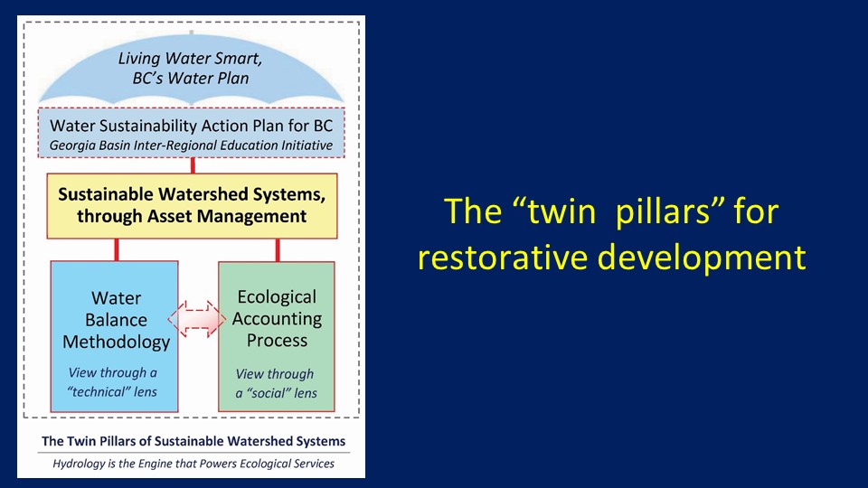
Ecological Accounting Process (EAP): Making it Straightforward for Communities to Calculate “THE WORTH” of Ecological Services and Incorporate in Financial Plans!
The concept of natural capital and natural assets can be a challenge to integrate effectively into asset management practices. Local governments need “real numbers” to deliver outcomes and support decision making. EAP deals with a basic question: what is a creekshed WORTH, now and in future, to the community and various intervenors?
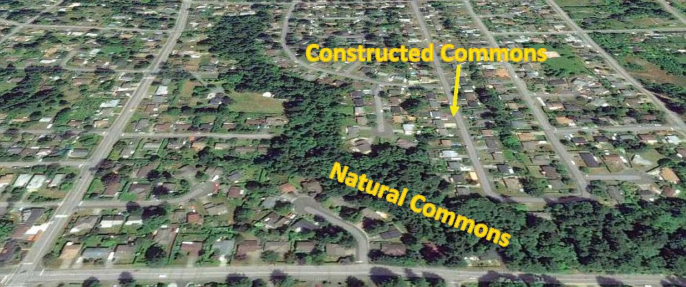
The Role of the Commons
“When land use and development occur, management of rainwater is a primary design and construction challenge. Land parcels may be platted to enable settlement uses; however, the hydrology of a watershed cannot be sliced and diced. As a result, communities devise management strategies that rely on the constructed commons to obtain infrastructure services needed,” states Tim Pringle, Chair of the Ecological Accounting Process (EAP) initiative.
 “Communities also rely on the natural commons to secure amenities and intrinsic natural services provided by ecological systems. This reliance suggests that an implicit contract to maintain and enhance the commons exists between the community and the governing authorities.
“Strategies that understand both the constructed and natural commons are essential to achieve water balance and improve maintenance (prevent degradation) and management (enhance) of watershed and creekshed hydrology. The Ecological Accounting Process (EAP) supports practitioners (key intervenors) involved in rainwater management and protection of ecological services.”
TO LEARN MORE:
Download PARKSVILLE SYMPOSIUM AGENDA.
To read the consolidated story of all four modules on Day Two, click on RESTORATIVE LAND DEVELOPMENT: Parksville 2019 Symposium organizing committee releases the Detailed Agenda for Day Two (April 4) – “Getting It Right by Making Better Land Use Decisions”.