
Province forms coordinating team to promote 'Sustainable Drainage' on Vancouver Island
The History of VICT
In 2006, three provincial Ministries and the federal Department of Fisheries and Oceans (DFO) formed a Vancouver Island Coordinating Team to facilitate a consistent, science-based approach to rainwater management on Vancouver Island. The three Ministries were Environment, Agriculture & Lands, and Community Services.
Connection with the Water Balance Model
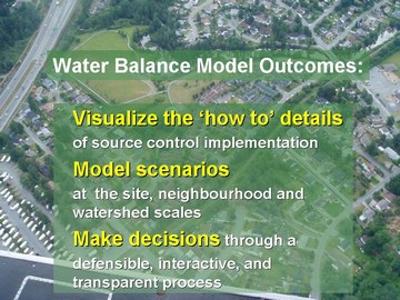
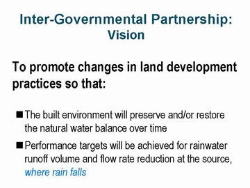
Achieving a consistent approach is keyed to use of the Water Balance Model for British Columbia, a web-accessible decision support and scenario modeling tool that was developed in 2003 by an inter-governmental partnership. The mission of the partnership is to promote ‘sustainable drainage’ practices province-wide.
The vision for a Water Balance Model VI Coordinating Team originated with Jay Bradley (Ministry of Agriculture & Lands), a member of the Water Balance Model steering committee. Prior to joining the Ministry, Jay had been a planner in local government and was responsible for both the District of Highlands and the District of Metchosin becoming members of the Water Balance Model partnership.
Initially established as a regional sub-group of the Inter-Governmental Partnership, the mission of the Coordinatirng Team was expanded in 2007 and it also became the local government arm of CAVI – Convening for Action on Vancouver Island.
This dual role led to a shortening of the name to Vancouver Island Coordinating Team and the use of the acronym VICT.
Water Balance Model training provided impetus for VICT
In December 2006, VICT met with the Cowichan Valley Regional District and two member municipalities (Duncan and North Cowichan) to initiate the pre-planning for a Water Balance Model Training Workshop that would be held in the Cowichan Valley.
 This exploratory session had its genesis in an initiative started a year earlier by Kate Miller when she was employed by the Cowichan Tribes. At that time, Environment Canada had proposed collaborating with the Cowichan Tribes to provide Water Balance Model training for the development community.
Making It Happen:
“Our Ministries decided to align our efforts and collaborate with DFO because we  believe this will enable us to be collectively more effective in achieving desirable rainwater management outcomes. We are providing local governments and the development community on Vancouver Island with the tools and experience that will help them design with nature”, explained Jay Bradley (Ministry of Agricultural and Lands), team leader.

WBM developed as an extension of the Guidebook
Developed as an extension of Stormwater Planning: A Guidebook for British Columbia, the Water Balance Model enables users to visualize how to implement rainwater runoff  source control solutions. “Because people typically need numbers to understand what an infrastructure decision means on-the-ground, the tool helps users wrap their minds around the implications and achievability of performance targets for capturing rainwater where it falls”, added Peter Law (Ministry of Environment) who was Chair of the Guidebook Steering Committee.
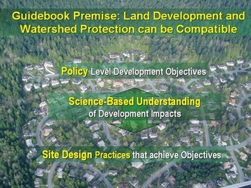
Published in 2002, the Guidebook was the catalyst that has resulted in British Columbia being recognized internationally as a leader in implementing a natural systems approach to rainwater management. The Guidebook’s premise that land development and watershed protection can be compatible represented a radical shift in thinking in 2002. The Guidebook recognized that water volume is something over which local government has control through its infrastructure policies, practices and standards.
The next evolution: Beyond the Guidebook
In 2003, the main focus of the Water Balance Model was on the use of source controls for runoff volume reduction to protect property, habitat and water quality. “Less volume means less flooding of agricultural and/or suburban lowlands. This is one reason why the Water Balance Model has emerged as the rainwater management tool of choice in making sustainable land development decisions – it demonstrates how to achieve a light hydrologic footprint”, observed Jay Bradley.
 “Provincial grant programs no longer support the traditional ‘pipes and pavement’ approach to drainage planning. The Ministry of Community Services focus is on programs that reduce rainwater runoff volume at the site level, by capturing rain where it falls”, reported Chris Jensen (Ministry of Community Services).
To advance the state-of-the-practice in rainwater management, in 2006 the Inter-Governmental Partnership had begun rolling out an initiative the Province called “Beyond the Guidebook”.
According to Jay Bradley: “This will take the Guidebook innovation to the next level of evolution. ‘Beyond the Guidebook’ has two precedent-setting elements: correlating runoff volume and stream health; and quantifying the relationship between the urban forest canopy and the interception of rainfall volume. Stay tuned!”
Integration with QUALHYMO:
To sustain the early success of the Water Balance Model, and in response to ‘needs and wants’ identified through discussions with the Alberta Low Impact Development Partnership (ALIDP) and others, the British Columbia Inter-Governmental Partnership (IGP) is moving along a pathway that will materially expand the capabilities of the web-accessible Water Balance Model: After evaluating how to most effectively enhance the hydrology engine, the decision was made to merge the Water Balance Model with QUALHYMO. For more information, please click here.
Posted December 2006
Updated September 2009