“Slow, Sink and Spread Rainwater Runoff” – online video tutorial guides homeowners in use of Water Balance Express
Note to Reader:
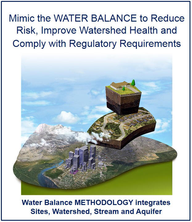
Funded by Metro Vancouver and a federal-provincial program for climate change adaptation, the Water Balance Model Express for Landowners helps landowners quantify how well their properties slow, sink and spread rainwater runoff and do their share to meet pre-set watershed targets for volume, infiltration and flow. The tool is integrated with Google Maps / Earth and the land use zoning of partner local governments. Six local government applications of the tool are now operational. An online video tutorial provides step-by-step guidance on use of the Water Balance Express.

To view the video, click on the image above or on https://vimeo.com/159415594
To test drive the WBM Express, visit www.waterbalance.ca or waterbucket.ca
“Water Balance Express for Landowners” – online tool is a key part of solution for restoring “environmental flows” in urban streams as watersheds re-develop
Water Balance Express video is an outcome of collaboration
The Partnership for Water Sustainability in British Columbia teamed with the Master of Land and Water Systems Program at the University of British Columbia and the Environmental Services Division at the Cowichan Valley Regional District (on Vancouver Island) to develop the video tutorial.
“ Three individuals played key roles in creating the video, namely Julie Wilson of UBC, Jeff Moore of Cowichan Valley and Jim Dumont of the Partnership,” states Ted van der Gulik, Partnership President. “Julie produced and narrated the video, Jeff wrote the script, and Jim provided technical oversight. Their collaboration has provided the Partnership with a valuable educational tool.”
“The first public showcasing of the video was at the 2016 annual conference of BC landscape architects. We approached this as a focus group test. The feedback was enthusiastic.”
Water Balance Express engages the user
 “The Water Balance Express tool allows people to think about water in a different way, by conceptualizing how it behaves as it moves on and around their property. They can see how the built environment (roofs, driveway) and natural features (soil type, depth, vegetation) change the movement or storage of that water,” reports Julie Wilson.“But it’s more than just a conceptual tool, it has a really well-designed interface, where users can create a simulation of their own property. People can locate their property on a map, recreate their current house and yard, and then like Lego, add building blocks of different rainwater management features to the property, to reduce their property’s runoff and infiltrate more water into the soil.”
“There is immediate gratification in seeing the Stream Health gauge move into the ‘green’ zone, indicating you are below your runoff target and reducing the theoretical impact on the stream. It is fun to use!” concludes Julie Wilson.
Enhanced Usability + Greater Flexibility
Jeff Moore is an Environmental Analyst with the Cowichan Valley Regional District. He has made substantial contributions to the ongoing evolution of the Water Balance Express, in particular the GIS-based interface with Google Maps/Earth.
“ The Google Maps interface provides a number of important benefits to users. The enhanced resolution, address search function, and ability to zoom-in to individual properties means that homeowners and developers can quickly and easily pinpoint the exact location of their property. This takes the guesswork out of identifying the watershed in which their property lies,” explains Jeff Moore.
“Working with Ian Smith (Water Balance team) and the Comox Valley Regional District, we were able to use this enhanced resolution to allow property-specific targets to be set for retention and infiltration based on both the watershed characteristics and the amount of impervious surface allowed by the zoning. This provides enhanced usability for homeowners and developers along with greater flexibility for local governments.”
“My goal in developing the script for the tutorial was to explain how to use the tool, and also how the various building blocks affect the stream health in both positive and negative ways,” concludes Jeff Moore.
Water Balance Express and ‘environmental flows’
 The flow-duration relationship is the cornerstone of the methodology. By maintaining flow-duration stability, this would prevent unintended stream erosion during wet weather while sustaining ‘environmental flows’ during dry weather. When homeowners slow, sink and spread rainwater runoff on their property, streams benefit.”“The new Water Sustainability Act will establish regulations pertaining to ‘environmental flows’ within the next few years. The Water Balance Express is a key part of the long-term solution for protecting stream health.”