Metro Vancouver Close Up (Video Series): District of North Vancouver’s Geoweb application is a useful tool for the public and municipal staff
Everyone from the mayor to solar panel installers are using Geoweb to harness the power of geographic information systems
Have you ever wondered if solar power could help reduce your electric bill? Or wished to know more about the history of a property, before you put in an offer? Those are just two examples of the uses people are finding for the District of North Vancouver’s Geoweb applications.
Harnessing Geographic Information Systems
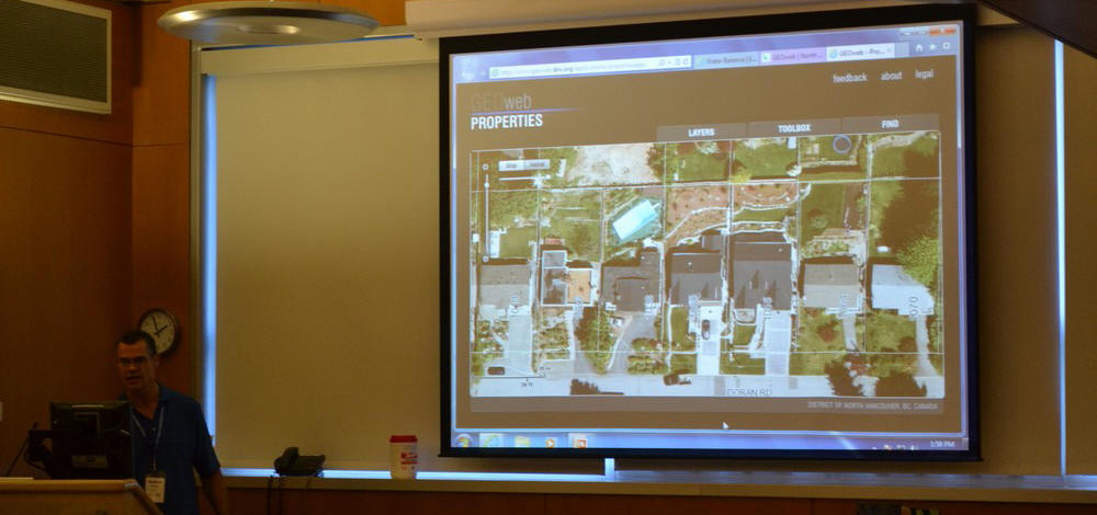
“Geoweb is a GIS website that’s created and maintained by the GIS department here at the District of North Vancouver,” explains Andrew Durnin, GIS Coordinator for the District of North Vancouver.
Even Mayor Richard Walton is finding a use for Geoweb.
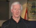 “I get property owners almost every day with questions, queries, comments. – I can quickly go into Geoweb and bring that property up right away and not only take a look at the property, but I can take a look at the details. I use it daily. I don’t even think about it. It’s like email, I’m into Geoweb virtually every day.”
“We use it to provide service to the organization and the public,” adds Durnin.
Solar Power Suitability
Users can see many layers of environmental information including one that rates a home’s suitability for solar hot water heating.
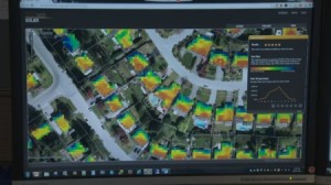 “We worked with the department of forestry at UBC to do some solar modeling to model the solar radiation that reaches the roofs of people’s houses,” says Durnin. “We found people started to use it, especially installers started to use it to assess whether or not it was a suitable location to install solar hot water.”
Faster Response in the Field
Having access to critical information while out in the field lets staff respond faster to a wide range of situations. Richard Boase is the Environmental Protection Officer for the District of North Vancouver.
“District staff are using the mobile phone Geoweb app – to help us with things like pollution spill response. Having the Geoweb tool available on our smart phone now allows us to access the entire district storm sewer network to help us track the  source of different kinds of pollution.”
Perhaps one of the map’s greatest uses for future planning is its ability to help people look back. Boase explains how the archival images in Geoweb provides a way to see how the District’s land use has changed over the years as forests have given way to development.
Using the Past to Understand the Future
 “The Geoweb air photo tool allows people to look at the land from an overview and help discuss and talk about the changes that come about because of urbanization and the changing we making to the landscape as we are developing our region,” reports Richard Boase.

OPEN DATA, APPS & MAPS: Since 2001, GEOweb has been empowering citizens through easy access to rich datasets and powerful applications. To learn more about its capabilities, visit geoweb.dnv.org
To Learn More:
In 2014, the Across Canada Workshop Series on Resilient Rainwater Management showcased the case study experience of those who are leading change in BC. The program introduced audiences in Alberta, Ontario, Quebec and the Maritimes to the Water Balance Model Express for Landowners; and to the District of North Vancouver’s GEOweb open data portal.
The power of these two web-based tools in combination wowed audiences across Canada. To learn more, click on District of North Vancouver’s “GEOweb Open Data portal” empowers citizens through information.
In addition, GEOweb is incorporated in the curriculum for an online course on Urban Watershed Management at the University of British Columbia. The faculty members who teach the Master of Land and Water Systems Program have developed an online tutorial that provides step-by-step guidance on use of GEOweb in combination with the WBM Express.
To learn more, click on URBAN WATERSHED MANAGEMENT: Online video tutorials introduce GEOweb & Water Balance Model Express for Landowners
The District of North Vancouver’s Richard Boase wowed the Calgary audience with a live demonstration that showcased the capabilities of the District’s GEOweb open data portal. This primed the audience for a live demonstration of the Water Balance Model Express for Landowners.