Water Balance Model Express for Landowners: Meeting Watershed Targets at the Site Scale in North Vancouver District
NOTE TO READER:
In 2012, the Metro Vancouver Regional Board provided a grant to help fund development of the Water Balance Model Express. The Board recognized that the ‘WBM Express’ will help Metro Vancouver members better deliver on regulatory compliance, and in particular the Minister’s conditions of approval. The WBM Express is a web-based tool.
The Metro Vancouver grant triggered funding from the Regional Adaptation Collaboratives (RAC), a federal-provcincial program that has supported coordinated action towards regional climate change adaptation decision-making by local government.
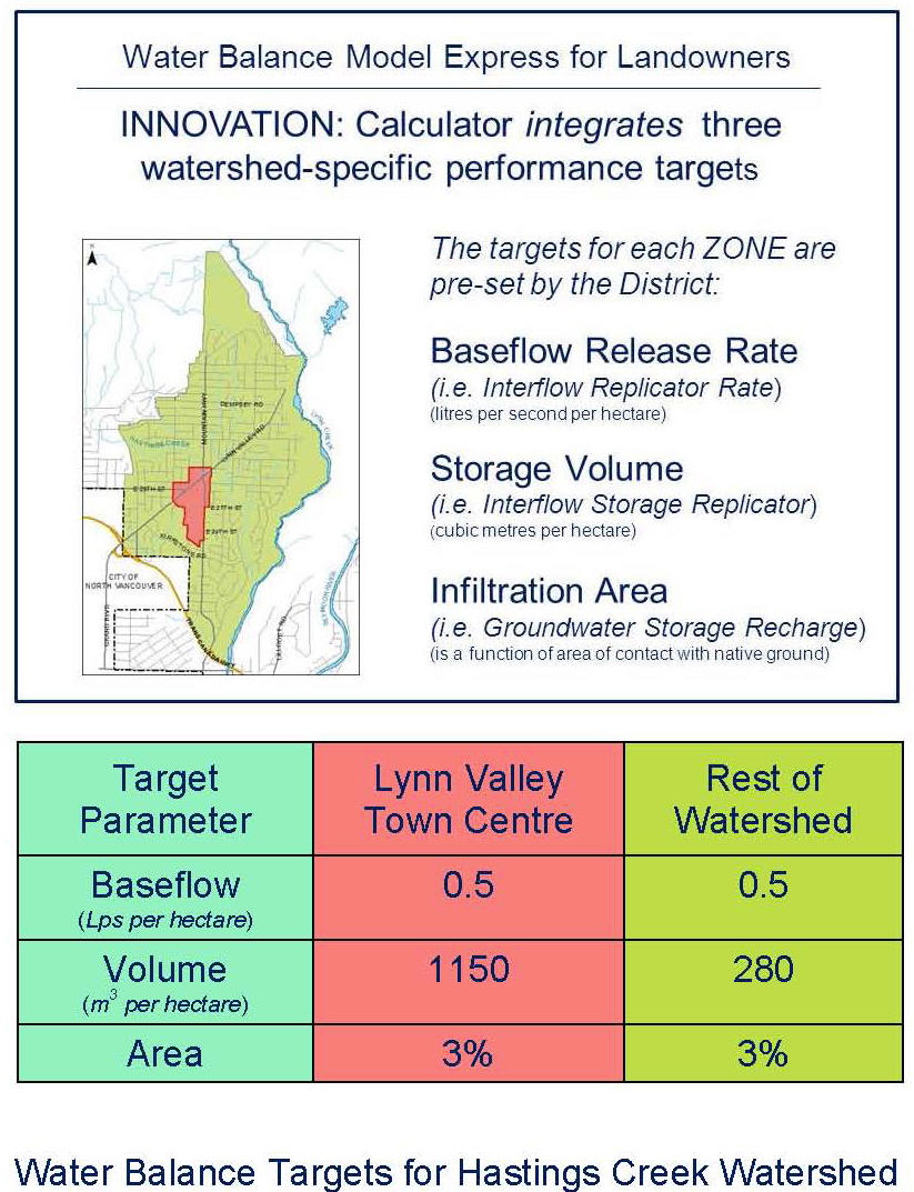
The District of North Vancouver’s innovative approach to development of the Hastings Creek Watershed Blueprint has produced a provincially significant precedent. The Hastings Blueprint showcases a demonstration application of the Water Balance Model Express.
To download a copy of the “Story of Hastings Creek”, click on A Watershed Blueprint for Hastings Creek: Creating the Future in the District of North Vancouver.
Water Balance Restoration Strategy for Hastings Creek Watershed
 “For years, the cumulative impacts of a changing landscape on Hastings Creek have been apparent. We are seeing channel erosion, bank instability and loss of aquatic habitat. These impacts have financial consequences for the District,” states Richard Boase, the District’s Environmental Protection Officer and the co-champion for the Hastings Creek Watershed Blueprint.
“As our understanding of the science behind stream and watershed health has progressed, it has also become clear that redevelopment is an opportunity. We have the tools. We have the understanding. It is a matter of applying both to ‘get it right the second time’. Implement a design with nature approach. Install green infrastructure that restores the Water Balance.”
 “The WBM Express represents a bold leap forward in the practice of urban drainage. At last local governments have a tool that integrates the SITE with the WATERSHED and the STREAM. The Express strips the challenge of setting and implementing targets to its essence,” states Ted van der Gulik, Chair of the inter-governmental Water Balance Model Partnership.
Prevent Erosion and Protect Stream Health
“Under natural conditions, flow in a stream reaches the stream through several pathways and over different time scales. The process starts with the ability of the landscape to absorb rainfall. It continues with movement of water through the ground. Replicating these conditions in an integrated  manner holds the key to restoring the Water Balance over time,” explains Jim Dumont, Engineering Applications Authority for the Water Balance Model Partnership.
“In engineering terms, the design objective is to manage stream energy to reduce or limit stream erosion, while at the same protecting water quality. Erosion is caused by the combination of volume and flow duration. The cause-and-effect relationship boils down to this equation: less volume equals less erosion. However, too little flow means no fish.”
WBM Express is Aligned with Other Regulatory Tools
“The recently adopted Official Community Plan provided the impetus to start a conversation about a vision to restore the rainfall absorptive capacity of the single family residential landscape. This vision is the essence of a Water Balance Restoration Strategy,” states Richard Boase.
“Also, there is now a provincial regulatory requirement that connects lands use and stream health. How the District implements the WBM Express to achieve performance targets for rainfall capture in single family areas needs to be a joint effort of engineering and planning. We are now poised to have the internal conversation about how to do this.”
“The District’s Development Servicing Bylaw provides a relevant frame of reference for implementing the WBM Express,” continues Steve Ono, the  District’s Deputy General Manager (Engineering Services). The bylaw references use of the Water Balance Model. The bylaw also contains language that clearly identifies that flood risk and erosion be maintained at rates that approximate the natural forested watershed.”
“It is implicit in the bylaw language that the Water Balance of developed conditions should also meet that of the natural forested watershed. This means that both infiltration to ground and flows in the stream should be maintained, or restored. The proposed targets would do this.”
TO LEARN MORE:
To read the complete story as described in Section 8 of “A Watershed Blueprint for Hastings Creek”, click on Water Balance Model Express for Landowners.