District of North Vancouver experience in applying the Water Balance Model to develop a watershed restoration vision
Note to Readers:
In October 2010, the Okanagan Basin Water Board (OBWB) and the BC Water and Waste Association are co-hosting a 2-day workshop titled ‘From Rain to Resource: Stormwater Management in a Changing Climate‘. The purpose of Day 2 is to integrate the perspectives of the people working on the ground and those developing and adopting policy.
Richard Boase, Environmental Protection Officer with the District of North Vancouver and Co-Chair of the Inter-Governmental Partnership, will elaborate on how his municipality is applying the Water Balance Model for British Columbia to develop a policy framework that will enable the District to achieve a watershed restoration vision.

Drivers for Watershed Restoration
“As early as 1997 the District of North Vancouver began to realize that rainwater management and not ‘storm water’ management was the key component to protecting quality of life, property and the small watersheds in North Vancouver District,” states Richard Boase.
 “Despite a significant amount of park and natural lands, our urban watersheds continued to exhibit signs of stress and destabilization. Increased incidences of erosion and flooding were a genuine concern among residents with land close to these watersheds.”
“Combined with information provided by local NGO’s who were calling for action to revitalize declining wild salmon populations we realized that we needed solutions quickly.”
Search for Solutions
“How does a municipality with no significant green field development fund traditional and expensive watershed restoration such as land acquisition and infrastructure replacement?,” Richard Boase asks rhetorically.
“The answer was not obvious; and we are still looking for it. We needed to look elsewhere for more immediate and widely applicable solutions. We turned our attention to the natural landscape comprising our single family zoned lands and neighborhoods.”
Application of the Water Balance Model
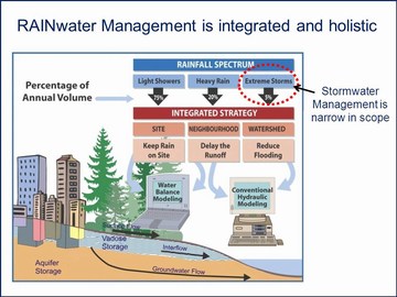
“We saw the Water Balance Model as an important tool that would help us to work within our developed community to restore function and value based on the premise that developed land can contribute to watershed restoration. To do this we turned our attention to the soil and trees that make up our landscape.”
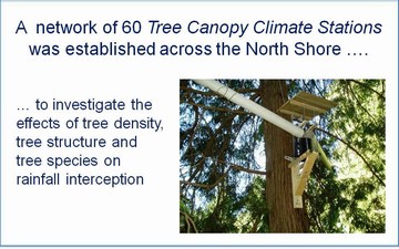
“By 2011, the Water Balance Model will incorporate a new Tree Canopy Module so that the rainfall interception benefits of trees in the urban environment can be quantified. Development of this module is based on actual interception data collected here on the North Shore. To populate the module with local data a collaboration with the University of British Columbia on a research program was reached.”
“At the From Rain to Resource Workshop in Kelowna, I will demonstrate how the use of the Water Balance Model has helped the District of North Vancouver to develop a watershed restoration vision based on the simple objective of leveraging redevelopment and neighborhood retrofit into opportunities for landscape based watershed restoration.”
Making Informed Political Decisions
“A key message from the District of North Vancouver experience is that Council is making informed decisions based on information derived from use of the Water Balance Model. Currently, District staff members are meeting with our politicians in a series of Council Policy Workshops discussing the function of trees on private lands.”
Reducing Red Tape
“In what can only be described as progressive forward thinking, DNV Council has asked staff to research opportunities for working with our community to reduce red tape around very large dominant trees, while at the same time ensuring that important community values are sustained.”
“Our current OCP review is taking a similar approach in that we are looking at all our land base, including single family zoned lands, to provide opportunities to restore watershed and stream health.”
Mackay Creek Case Study
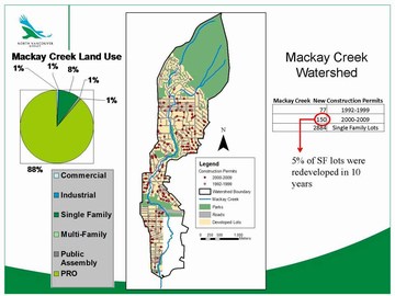
“Using the Mackay Creek Watershed as a case study, we have demonstrated to Council that the importance of hydrologic function associated with lands removed from the stream corridors is not only being overlooked but is contributing to the erosion of stream health. An improved water balance on the individual lot can be shown to arguably provide more benefit to improvements in stream health than the thin riparian strips that we zealously protect.”
“To capture Council’s attention, we projected what the future could look like — in the Mackay Creek watershed — if we continue to redevelop without addressing the impact of the change in the ‘hydrologic footprint’. Light bulbs went on when we showed Council 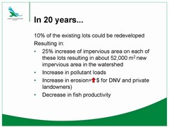 the numbers generated by the Water Balance Model, and explained what they mean.”
“Now Council understands why urban trees are important. Now we have Council direction to report back with ideas on how we might develop and implement a plan for maintaining a Tree Canopy Target at the residential site scale. We envision that the Water Balance Model will enable not only ourselves to work with property owners but property owners to work independently to achieve the target.”
To Learn More:
To download a copy of the presentation slides that guided the discussion with Council on October 5, click on District of North Vancouver Council Policy Workshop on Tree Protection
To learn more about watershed restoration, click on the links below
A crucially important message in Beyond the Guidebook 2010: “We now have the tools and experience to design with nature” — “So many in local government are searching for the magical ‘silver bullet’to resolve watershed issues and challenges. Yet soil, vegetation and trees can do more for our watersheds than decades of planning, consulting and complicated engineering design will ever achieve.”
The District of North Vancouver’s Bold Vision for a Municipality-Wide Integrated Rainwater Management Plan — “Through the Official Community Plan Update, the District is advancing a vision for restoring the rainfall absorption capacity of our watersheds, one property at a time, over time.”
How the Tree Canopy Protects Urban Stream Health: “The right trees in the right places intercept rainfall”, says IGP Co-Chair Richard Boase — “Trees can intercept upwards of 50% of the rain that falls each year on a watershed. Removing the tree cover means that more and more rainfall is converted into runoff volume.”
Water Balance Model can create an understanding of the past and compare it to many possible futures — “A key message is that the Water Balance Model is a ‘scenario comparison tool’. This is where the WBM shines as it is not constrained by starting or ending points. It compares whatever the user can envision.”
Beyond the Guidebook 2010 Advances Runoff-Based Approach to Setting Watershed Performance Targets — “A framework for developing integrated and holistic plans is consolidated in a single table. This ‘mind-map’ lays out the cascading logic for establishing, evaluating and implementing watershed-specific runoff targets that will protect stream health.”
Bowker Creek Blueprint brings new meaning in British Columbia to the Ian McHarg vision for “designing with nature” — “The Blueprint is a 100-year action plan to make the watershed restoration vision real. Watershed restoration is a long-term commitment. The Bowker Creek Blueprint is all about stakeholders committing to actions on the ground, one reach and one property at a time, over the next 100 years.