
Innovative Rainwater Management in the South Campus Neighbourhood at the University of British Columbia

Planning Context
In January 2004, the UBC Board of Governors approved a consultation process for a portion of South Campus. The result is a plan that has been formulated to be consistent with the University’s vision expressed in Trek 2010.
South Campus is a significant component of the University Town at UBC. The build-out of this neighbourhood will occur in the next five to ten years. A conventional commuter campus for much of its history, the university is returning to the original vision of its founding architects who in 1914 described “…a university city in an idyllic setting.”
The neighbourhood plan for the northeast area of the South Campus is for a sustainable community with both rental and market housing, a commercial area,  community centre, school, playing fields, parks and public open space.
“Sustainable strategies have been adopted for land use, rainwater retention, green roofs, landscape features and vegetation, park layout, vehicular and pedestrian routes, acess to public transport, building siting and orientation, building materials and infrastructure,” explains David Grigg, Associate Director – UBC Infrastructure Services & Planning.
 Sustainable Drainage Strategy
“Protection and enhancement of Booming Ground Creek has provided a driver for development and implementation of an innovative rainwater management strategy to serve the South Campus Neighbourhood,” continues David Grigg. To access a report that decribes the strategy, click on Sustainable Drainage Strategy for the South Campus Neighbourhood
Booming Ground Creek has historically drained portions of the South Campus area, and eventually flows through the portion of Pacific Spirit Park south of the campus. The creek channel has experienced problems with erosion and has sensitive habitat values in its lower reaches.
The portion of Booming Ground Creek upstream of SW Marine Drive in Pacific Spirit Park dries up during the drier summer months. The habitat value of downstream sections of Booming Ground Creek is dependent upon having year-round water flow.
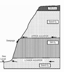 UBC soils in general consist of approximately 0.5m of organic topsoil, underlain by up to 30m of relatively impermeable glacial till. Below this level is the Quadra Sand unit, which incorporates the upper and lower aquifers that underlie much of Point Grey. The sand aquifer is key to the strategy for capturing, storing and pumping rainwater runoff to sustain baseflow in Booming Ground Creek.
To view a 5-minute YouTube video of David Grigg explaining the strategy elements to the Metro Vancouver Reference Panel, click on using the sand aquifer as a reservoir to sustain flow in Booming Ground Creek.

Posted June 2009