A Plan for Rainy Days: Water Runoff and Site Planning
CMHC Research Highlight describes Water Balance Model application to Stratford Case Study
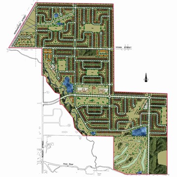
In 2004, the City of Stratford (population 30,000) in Ontario approved a secondary plan for a future city expansion area of 155 ha, based on an evaluation of three plans, one of which was derived from the CMHC (Canada Mortgage & Housing Corporation) planning model, the Fused Grid. This is explained below.
Since all three plans protected site watercourses and included stormwater management ponds as a requirement, the evaluation criteria did not include rainwater runoff impacts. In 2006, CMHC initiated a supplementary case study to assess the potential for reducing or eliminating rainwater runoff from the development area.
The case study involved application of the Water Balance Model for Canada, with the goal of enabling planners, developers and municipal officials to make informed choices about the most effective ways to retain more water and reduce or prevent runoff, which promotes groundwater infiltration and regeneration of the water supply.
The question for this analysis was to assess to what extent street layout, amount and distribution of open space, and building form affect the post-development runoff resulting from the impermeable surfaces that urban development creates. To download the Technical Highlights publication produced by CMHC, click on this link to A Plan for Rainy Days – Water Runoff and Site Planning.
Using the Water Balance Model, the Stratford case study examines the impact of several techniques to reduce runoff. One set applies to the individual lots, such as absorbent landscape, rain gardens and pervious pavers. Another set applies to streets, such as in-street infiltration trenches, absorbent boulevards and sidewalks combined with storage underneath.
The Stratford project is proceeding, and the first phase of neighbourhood development comprises 8 hectares. It follows the original plan in essence.
Fused Grid Explained
The “Fused Grid” is a neighbourhood and district layout model. It combines the geometries of inner city grids and of the conventional suburbs. This fusion results in retaining the best characteristics of each and none of their disadvantages while raising the quality of the neighbourhood environment.
 The planning model was developed by Fanis Grammenos, a senior researcher at the CMHC in Ottawa, and a team of colleagues. It combines two traditional street designs: the conventional loop and cul-de-sac pattern of the modern suburb and the grid pattern from the early 1900s.
According to Grammenos, “The traditional grid pattern provided efficient routes and “connectivity” for pedestrians and those travelling by horse and buggy. The loop and cul-de-sac pattern reduces the impact of traffic on a community.” Through his research, Grammenos discovered that residents want the best of both street patterns. In particular, they want connectivity, safety and the tranquility of quiet spaces.
“It was apparent that these qualities needed to be established in a new pattern, because the old pattern would not deliver the new qualities,” Grammenos says. He also found in examining market research and buying patterns that people prefer quiet neighbourhoods without through streets.
“People have consistently paid more money for houses located at the top of a cul-de-sac, near a ravine, facing a golf course or having a view of a lake,” Grammenos says. “Generally, people have paid more money willingly to have a view of nature and be as quiet as is feasible in the environment that they choose to live in.”
The fused grid is inspired by a theme — the common space — from an 18th-century plan of Savannah, Georgia. “The city plan is organized in repeatable wards, with a square in the centre, which is visible to half of the homes in each ward”, explains Grammenos, “The square is protected from heavy traffic since through streets are located at the boundaries of the ward, leaving the centre relatively calm for casual strollers.”
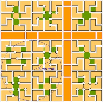
The Fused Grid translates that concept into four 16-hectare (40-acre) quadrants. “The four quadrants are separated by simple collector streets that connect residents of the quadrants to surrounding arterial streets, which act as major transportation routes”, continues Grammenos, “For convenience, a commercial strip is located at the perimeter of the four quadrants between twinned roads where traffic is concentrated.”
Within each quadrant, residential streets are laid out in a modified grid to prevent cars from crossing the quadrant, eliminating non-resident traffic. Because the streets are looped and narrow, notes Grammenos, they reduce the speed of all traffic and make more efficient use of land. The streets, and all parts of the neighbourhood, connect to a central public park that is intended to be a meeting place. “That not only increases the possibilities for social interaction, but also increases the delight that people derive when facing open green space,” Grammenos says.
A pedestrian footpath through the open spaces connects the streets and provides direct routes for residents to parks, public transit, entertainment, stores and services. “Residents can walk diagonally through the quadrant in about five minutes”, concludes Grammenos.
To Learn More:
For more about the Fused Grid and the work of Fanis Grammenos, click on this link to The Fused Grid: A Contemporary Urban Pattern.