
“ISMP Course Correction” Showcases Tools and Case Study Experience to Help Restore Watershed Health
Note to Reader:
The commitments by Metro Vancouver and member municipalities to develop ISMPs (Integrated Stormwater Management Plans) and implement on-site rainwater management are spelled out in the region’s Integrated Liquid Waste & Resource Management Plan. To help local governments fulfil their regulatory commitments, the City of Surrey hosted the pilot for a 2-day “Course on the ISMP Course Correction” in November 2011.
The course is designed for planning, engineering, environmental, asset management and other practitioners who make decisions that ultimately impact on land use, infrastructure or stream health.
Protect Interflow
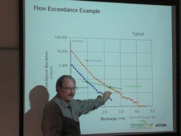
“The Department of Fisheries and Oceans has identified the interflow system as an incredibly important and yet fragile component of a watershed. Interflow is critical for maintaining stream health and the fishery resource. The course will teach how to protect and restore interflow by installing a simple Interflow Replicator on development sites. The function is to replenish low flows to the stream,” states Jim Dumont, Engineering Applications Authority for the Water Balance Model Partnership. He is a member of the teaching team.
“Two primers provide the technical foundation for the course curriculum. The Hydrology Primer and the Watershed Modeling Primer cover the basics and are suitable for engineers and non-engineers. The primers will help everyone make informed decisions about how to apply a science-based understanding to restore watershed function.”
See Not, Regulate Not?
“Interflow is a part of nearly every watershed; however, I know there will always be an exception. The exception occurs where the watershed is underlain by coarse grained soils. Everywhere else there is a thin layer of bio-chemically altered material called, top soil, underlain by a finer silty or clay subsoils,” continues Jim Dumont.
“It is in these instances that the water accumulates and flows as interflow through the topsoil as it follows the path of least resistance; through the topsoil rather than through the underlying tighter soils. This explains why surface flows from pervious surfaces are often observed to be nil and a catchment contribution to a stream is then ignored.”
“This situation arises simply as a result of the modelling process for design storms or the rational method that lumps any water that infiltrates through the surface as a ‘loss’. All the while it may well be moving sideways down slope to the stream through shallow surficial soils. Unseen and hence ignored because it has been deemed to be unimportant.”
“The question is whether is it important enough to become a regulatory issue. I am not aware of this being an item that regulators in other jurisdictions acknowledge or review. I believe the old adage can be reworded to include: ‘see not’, regulate not’,” concludes Jim Dumont.
To Learn More:
“It is now time to take another leap forward, albeit by moving sideways, and recognize near surface lateral water flow, otherwise known as interflow,” states Alan Jonsson, Habitat Engineer with Fisheries and Oceans Canada.
 “Interflow is often the dominant drainage path in glaciated landscapes of British Columbia. Even undeveloped sites that are founded on till and bedrock rarely show overland flow because of interflow pathways. The challenge for engineers is to determine the influence of interflow on a site and then design and implement techniques that replace or restore it.”
To read the complete story posted elsewher on Water Bucket, click on “Understand How Water Reaches the Stream and Design for Interflow”, urges Department of Fisheries and Oceans.
From Guidelines to Tools
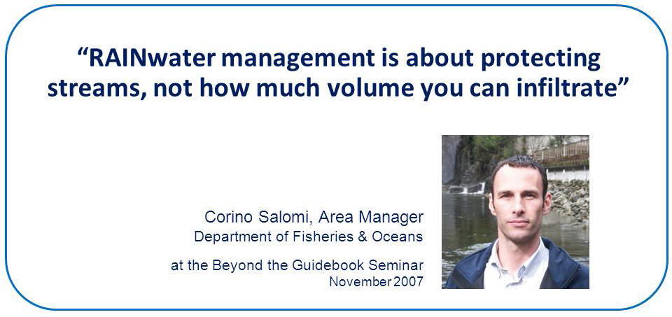
“We are moving from guidelines to tools,” states Corino Salomi of the Department of Fisheries and Oceans (DFO). He is Area Manager, Oceans, Habitat & Enhancement Branch, Lower Fraser Area.
“It helps to look back to understand how we got to here. In November 2000, DFO released the 4-page Urban Stormwater Guidelines and Best Management Practices for Protection of Fish and Fish Habitat, Draft Discussion Document. That document set a direction.”
“By 2007, however, we had concerns about how the document was being interpreted and applied. The Beyond the Guidebook initiative initiated a course correction that will help local governments and the development community establish what level of rainwater runoff volume reduction makes sense at the site, catchment and watershed scales.”
“The objective is protect stream health, which is broader than how much volume one can infiltrate on a particular development.”
To Learn More:
To read the complete story posted elsewhere on the Water Bucket website, click on Application of the “DFO Urban Stormwater Guidelines” has evolved over the past decade to protect stream health.
Posted November 2011